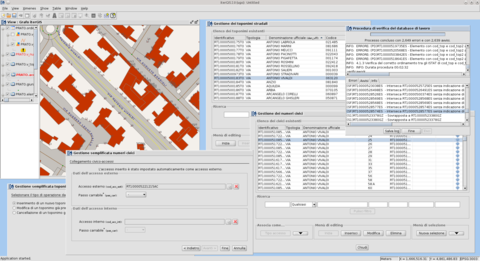
iter.GIS – Desktop based application to manage toponymy data among Tuscany Region
Regione Toscana founded a regional project named iter.net (http://www.iternet.fi.eng.it/SigmaPortal2) to set up a communication infrastructure that allows toponymy data transfer from Local Entities to Regione Toscana itself, using regional transfer infrastructure known as CART (http://www.cart.rete.toscana.it).
As a strategic component of such a design, Regione Toscana needed an application to enable Local Entities to manage road network and street numbers and to transfer updates through CART.
gvSIG was selected as the frame work to develop iter.GIS, that is mainly an extension to gvSIG itself enabling:
-
road handling;
-
street numbers management;
-
topological requirement compliance;
-
model adherence;
-
updates forwarding through web services.
gvSIG was enhanced in its PostgreSQL interface and tailorized to small Municipality needs using guided interfaces (wizards) to enable GIS-unaware users to accomplish the goal of updating road network and street numbers.
iter.GIS main benefits are:
-
model homogenization, thanks adherence to iter.net project whose data model derived from Italian “Intesta Stato-Regione-Enti Locali” board, itself based of European model INSPIRE;
-
task simplification, enabling users to correctly modify road network and street numbers without requiring a strong GIS knowledge.

