gvSIG Outreach
a place to boost the promotion of gvSIG products and community
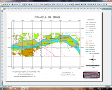
Use of geoprocessing through buffers and intersect tools, for the delimitation of not allowed areas to the dredging of sand in the stream bed of rivers (50 meters of the edge) and overlapping buffer limits.