Skip directly to content

Creative Commons CC-BY-SA 3.0

6th LAC gvSIG Conference Image

on Tue, 04/02/2014 - 14:45
Author: 
Helen Teixeira
License: 
Creative Commons CC-BY-SA 3.0
Spread type: 

gvSIG plain logo for gis.stackexchange.com

on Mon, 28/10/2013 - 17:27
Author: 
Jorge Sanz
License: 
Creative Commons CC-BY-SA 3.0
Spread type: 

9th International gvSIG Conference Image

on Wed, 14/08/2013 - 11:55
Author: 
Mario Ignacio Fèvre
License: 
Creative Commons CC-BY-SA 3.0
Spread type: 

5th LAC gvSIG Conference Image

on Wed, 29/05/2013 - 14:49
Author: 
Mario Ignacio Fèvre
License: 
Creative Commons CC-BY-SA 3.0
Spread type: 

Ríos de Uruguay

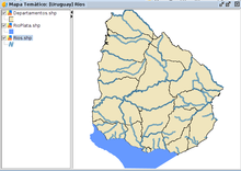
Contiene información de los principales ríos y afluentes de Uruguay.
Como cartografía base se utiliza una capa de Departamentos.
La cartografía utilizada se ha obtenido en: http://www.ceibal.edu.uy/Articulos/Paginas/GVSIGBatov_.aspx

Average: 3.3 (992 votes)

Pages