Skip directly to content

Public administration

gvSIG y SIGLAPALMA

Situation: 

Las dificultades que se presentan en el uso de esta información geográfica se basan en la escasez, dificultad de localización, desconocimiento de sus características, calidad, elevado precio y sobre todo en los obstáculos de difusión e integración con otros sistemas de información diferente del organismo que los genera.

Software: 
5
Average: 5 (1 vote)
Country: 

gvSIG and the Bétera City Council Planning Department

Georeferenciación de planos
Visualización de información puntual
Situation: 

The Bétera City Council Planning Department creates the Bétera Geographic Information System which purpose is the collection, analysis, maintenance and distribution of municipal information likely to be georeferenced, either alphanumeric or graphic. The main idea is achieve interoperability between public administrations and departments within the municipality located in different buildings and through mobile units.

Software: 
0
No votes yet
Country: 

gvSIG and CarThema 5.0

Situation: 

Migration to Java code of a graphical application developed in Delfi suitable for releasing of thematic charts.

Software: 
0
No votes yet
Country: 

gvSIG and the Project Campus

Situation: 

Campus project was initiated with a goal to prove that open source tools can successfully be used in public administration, and bring more benefit in total compared to commercial solutions.

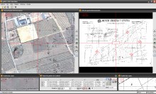
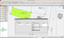
As a part of a wider project of Land Administration in Bosnia & Hercegovina, it concentrated on a desktop application suitable for editing and maintenance of geospatial data in a Cadastre office. Data are stored within open source Postgresql database.

Software: 
0
No votes yet

Pages