Skip directly to content

Quantum GIS

Analisys of contaminants and salinity in the Minho's river for the European Project

Situation: 

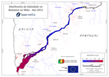
The project TEAM-Minho, led by the University of Vigo, brings together scientific partners and water administrations on both sides of the river Minho to develop common tools for the coordinated implementation of the Water Framework Directive in its estuary.The aim of this project is the establishment of uniform scientific criteria, valid for Spain and Portugal, allowing the definition, referencing and classification of ecological status of transitional water bodies in southern Galicia and northern Portugal.

Software: 
5
Average: 5 (6 votes)
Country: 

gvSIG applied to the management of the agricultural lands of the Lipetsk Region

Situation: 

To take decisions in the management of territory, the governor of the Lipetsk Region and the Heads of the municipal districts need an information about current state of the agricultural lands and its use. As a rule, that information is existing in the form of the paper maps and schemes, it's awkward in the daily work and doesn't reflect the real situation.

Software: 
5
Average: 5 (2 votes)
Country: 

Использование gvSIG в задачах управления землями сельскохозяйственного назначения

Situation: 

Для решения задач управления руководителям и специалистам органов исполнительной власти областного уровня и органов местного самоуправления муниципальных районов Липецкой области необходима информация о текущем состоянии земель сельскохозяйственного назначения и их использовании. Ранее такая информация была представлена в виде бумажных карт и схем, не отражала реального состояния и была труднодоступной.

Software: 
4.2
Average: 4.2 (5 votes)
Country: 

O uso do gvSIG na construção do SIG da Fundação Nacional do Índio (FUNAI)

Situation: 

A Coordenação Geral de Geoprocessamento precisava montar um Sistema de Informação Geográfica que atendesse as demandas internas da instituição, bem como as da comunidade por mapas e informações geoespaciais. Estas informações deveriam estar livremente acessíveis e os programas distribuídos nas diferentes coordenações sem impactar o orçamento institucional e estes deveriam interagir entre si de modo a minimizar as conversões dos dados entre eles.

Software: 
0
No votes yet
Country: 

gvSIG et la création d’un Schéma territorial des services au Pays de Ploërmel-Cœur de Bretagne

Situation: 

La mission consistait à recenser les services et équipements présents sur le territoire afin de dégager les caractéristiques et de voir les éventuels manques ou doublons. Elle devait être menée avec l’utilisation exclusive de logiciels libres. Parallèlement à cette mission principale plusieurs autres études ont été conduites et ont nécessité l’usage du SIG.

Software: 
5
Average: 5 (2 votes)
Country: 

Pages