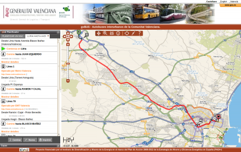
gvBUS : gvSIG and public transport
The Directorate General of Transport needed a GIS application to display all bus routes passing through Valencian Community (Spain). It had to include all bus stops which those bus routes have and the companies which manage them.
The Directorate General of Transport has introduced gvSIG to manage all the elements related to transport, such as routes, stops and so on.
Within this project an application called 'gvBUS' has also been developed. This web application enables anyone can consult all the routes that an user can use to make a trip between different cities in Valencian Community. It only includes the public transport routes.
gvSIG Desktop is used to edit and update the bus routes.
- Managing information more quickly
- Updating the bus routes very easily
- The gvBUS application also allows anyone to find updated information on the Internet about the different public transport systems in Valencian Community (Spain), enabling you to plan your routes and schedules

