Skip directly to content
User menu
gvsig.org
devel.gvsig.org
gvsig.com
blog
planet
twitter
gvSIG Outreach
a place to boost the promotion of gvSIG products and community
Main menu
Home
Maps
Case Studies
Scripts
Spread
Releases
Campus
Contribute
Contact
You are here
Home
Search form
Search
Popular content
Today's:
GIS open source framework for an interactive surface and groundwater modelling
Integration of i3Geo on gvSIG
gvSIG and CarThema 5.0
gvSIG applied to viticulture
gvSIG for Registration Mining
Continental
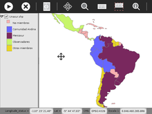
Unasur (2012)
Contiene información de los países miembros de Unasur, especificando los miembros de Unasur de la Comunidad Andina, de Mercosur, otros miembros y países observadores.
Data source:
http://www.naturalearthdata.com/
(Scale: 1:100million)
Select rating
Give it 1/5
Give it 2/5
Give it 3/5
Give it 4/5
Give it 5/5
Average:
3.3
(
15
votes)
Read more
about Unasur (2012)
Add new comment