Skip directly to content
User menu
gvsig.org
devel.gvsig.org
gvsig.com
blog
planet
twitter
gvSIG Outreach
a place to boost the promotion of gvSIG products and community
Main menu
Home
Maps
Case Studies
Scripts
Spread
Releases
Campus
Contribute
Contact
You are here
Home
Search form
Search
Popular content
Today's:
Creating basic metadata text files and exporting view's layers
Elevation points of the world
Orografía y Ríos de Uruguay
Analysis of the value chain for leather products in San Lorenzo street market
Welcome
ArcSDE
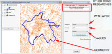
WG-Edit: a new gvSIG extension for the street cadastre management
Sectors:
Infrastructures
Public administration
Situation:
ArcView 3 is no more supported by ESRI
WgEDIT extension for ArcView3 is no longer supported
Avenue is an old language (it is difficult to implement new customizations)
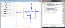
The basic road network and the attributes of the roads are currently managed by two different technologies
Software:
gvSIG Desktop
5
Average:
5
(
4
votes)
Country:
Italy
Read more
about WG-Edit: a new gvSIG extension for the street cadastre management