Skip directly to content

PostGIS

gvSIG and extDMSAR for Data Mining

Situation: 

There are large volumes of geographic data stored in geographic databases. But the organization of the data and the existing tools usually manipulate only explicitly stored data. They can't extract implicit knowledge. So, it is essential to develop new technologies for extracting that kind of knowledge (spatial relationships, other non-explicit patterns...) because data mining is very important to make decisions.

Software: 
4
Average: 4 (3 votes)
Country: 

gvSIG para Gestión Forestal : SIFOMAP 3.0

Situation: 

Una forma de organizar, planificar, y administrar los recursos forestales eficientemente y con integración de la información entre usuarios y proveedores lo constituye la utilización de los Sistemas de Información Geográfica como herramienta de soporte a las decisiones.

Software: 
2.333335
Average: 2.3 (3 votes)
Country: 

Using gvSIG to compute light pollution from night satellite images

Situation: 

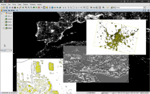
The night pictures taken from the International Space Station (ISS) and other NASA missions as DMSP can be used to compute light emission from ground based locations. We need a complete GIS toolkit to study correlations among the satellite images and light sources. So we can get information about individual buildings or geographical areas.
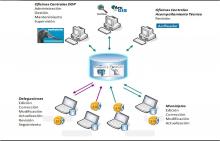
We need also a tool which can use standard OGC services to access Geographic information and Layers from other SDI (Spatial Data Infrastructure), as IDEE. The connection to spatial databases, as PostGIS, would be the last requirement.

Software: 
5
Average: 5 (4 votes)
Country: 

gvSIG and the “Habitat” Federal Program

Situation: 

For a good evaluation of the works and actions proposed by municipalities to get federal funding is necessary to have the geographical location of those works with exactness and on time for the various branch offices and central areas of the organization.

Software: 
4
Average: 4 (1 vote)
Country: 

Geographic Information System "City of Oncativo"

Situation: 

Based on the multi used land registry criteria, it was necessary an information system that:

  • Allows to access to urban land registry information
  • Allows to differentiate urban and rural borders.
  • Provides reorganization and public services information.
  • Allows to negotiate correctly the territorial information in order to take decisions referred to planning and urban development .
  • Allows to add social-economical information
Software: 
5
Average: 5 (2 votes)
Country: 

Pages